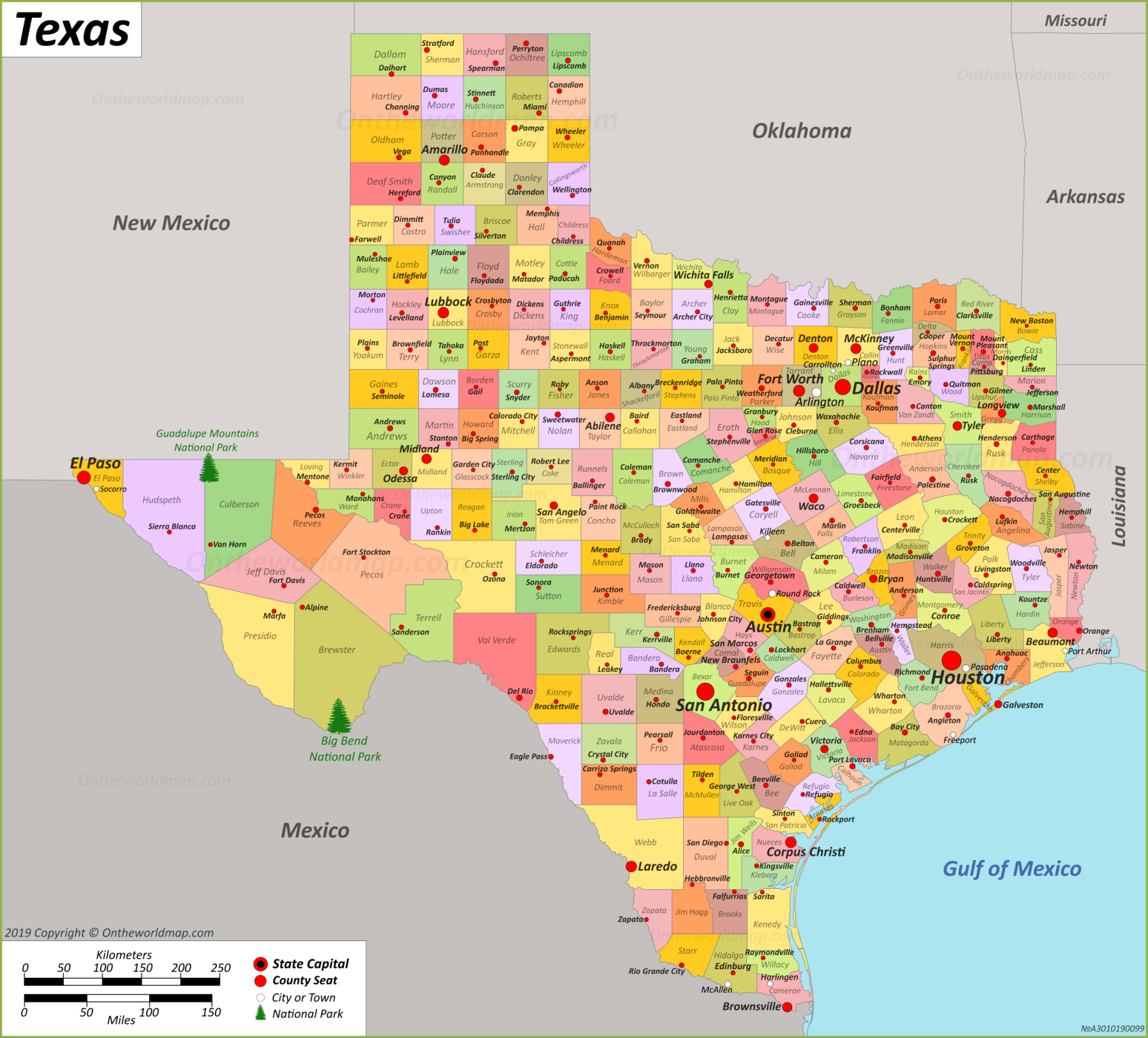
Texas Map

Description:
This map shows boundaries of countriesstates boundariesthe state capitalcountiescounty seatscitiestownsGulf of Mexicoislands and national parks in Texas.
Size: 2200x1990px / 1.52 Mb;
1800x1628px / 1.06 Mb;
1500x1357px / 411 Kb
Author: Ontheworldmap.com
You may downloadprint or use the above map for educationalpersonal and non-commercial purposes. Attribution is required. For any websiteblogscientific research or e-bookyou must place a hyperlink (to this page) with an attribution next to the image used.
Page Navigation
Texas Location Map

Online Map of Texas
Detailed Maps of Texas


Maps of the regions of Texas


Maps of Texas and Neighbouring States


Other Maps of Texas
Google Map of TexasOpenStreetMap
Bing Maps
USGS National Map
Texas National Map (National Atlas of the United States)
Texas Official Travel Map (pdf)
Texas Heritage Travel Guide Map (pdf)
About Texas
Texas lies in the south-central region of the United States. It shares borders with four U.S. states: Oklahoma to the northArkansas to the northeastLouisiana to the eastand New Mexico to the west. International bordersespecially with Mexicorun along the southwest and southern boundariesdemarcated primarily by the Rio Grande River. The Gulf of Mexico borders Texas to the southeastproviding significant coastline.
Austinthe capital of Texasalso serves as a major hub for technology and educationnotably housing the University of Texas. Other principal cities include Houstonthe state's largest city and a global energy center; San Antonioknown for its historical sites like the Alamo; and Dallasa key commercial and cultural nucleus.
Tourists flock to Texas for a variety of attractions and resorts. The Gulf Coastincluding cities like Galveston and Corpus Christioffers beaches and maritime activities. The state also boasts significant historical sitessuch as the San Antonio Missions National Historical Park. In Central Texasthe Texas Hill Country attracts visitors with its wineriesscenic landscapesand recreational opportunities.
Major attractions include the Space Center Houstona significant site for NASA operationsand Big Bend National Parkwhich offers extensive hiking and wildlife viewing opportunities. OverallTexas combines urbanhistoricaland natural attractionscatering to diverse visitor interests.
The Facts:

Flag of Texas |

Seal of Texas |
| Capital: | Austin |
| Largest city: | Houston |
| Area: | 268,596 sq mi (695,662 sq km) |
| Dimensions: |
|
| Latitude: | 25°50′ N to 36°30′ N |
| Longitude: | 93°31′ W to 106°39′ W |
| Population (2023): | 30,503,301 [1] |
| Density: | 114/sq mi (42.9/sq km) |
| Elevation: | |
| Official language: |
|
| Spoken language:[3] |
|
| Religion (2020):[4] |
|
| Racial/ethnic groups (2020):[5] |
|
| Median household income (2022): | $66,963[6] |
| USPS abbreviation: | TX |
| ISO 3166 code: | US-TX |
| Time zone: |
|
| Official website: | www.texas.gov |
List of The Largest Cities in Texas by population
| Rank | City | County | Population (2022)[7] |
|---|---|---|---|
| 1 | Houston | Harris | 2,302,878 |
| 2 | San Antonio | Bexar | 1,472,909 |
| 3 | Dallas | Dallas | 1,299,544 |
| 4 | Austin | Travis | 974,447 |
| 5 | Fort Worth | Tarrant | 956,709 |
| 6 | El Paso | El Paso | 677,456 |
| 7 | Arlington | Tarrant | 394,602 |
| 8 | Corpus Christi | Nueces | 316,239 |
| 9 | Plano | Collin | 289,547 |
| 10 | Lubbock | Lubbock | 263,93 |
| 11 | Laredo | Webb | 256,187 |
| 12 | Irving | Dallas | 254,715 |
| 13 | Garland | Dallas | 240,854 |
| 14 | Frisco | Collin | 219,587 |
| 15 | McKinney | Collin | 207,507 |
| 16 | Grand Prairie | Dallas | 201,843 |
| 17 | Amarillo | Potter | 201,291 |
| 18 | Brownsville | Cameron | 189,382 |
| 19 | Killeen | Bell | 159,172 |
| 20 | Denton | Denton | 150,353 |
| 21 | Mesquite | Dallas | 147,899 |
| 22 | Pasadena | Harris | 147,662 |
| 23 | McAllen | Hidalgo | 144,579 |
| 24 | Waco | McLennan | 143,984 |
| 25 | Midland | Midland | 134,444 |
| 26 | Carrollton | Dallas | 133,82 |
| 27 | Lewisville | Denton | 131,215 |
| 28 | Abilene | Taylor | 127,385 |
| 29 | Pearland | Brazoria | 126,949 |
| 30 | Round Rock | Williamson | 126,697 |
| 31 | College Station | Brazos | 124,319 |
| 32 | Richardson | Dallas | 118,802 |
| 33 | League City | Galveston | 115,418 |
| 34 | Odessa | Ector | 112,906 |
| 35 | Beaumont | Jefferson | 112,089 |
| 36 | Allen | Collin | 111,551 |
| 37 | Sugar Land | Fort Bend | 109,414 |
| 38 | Tyler | Smith | 109,286 |
| 39 | New Braunfels | Comal | 104,707 |
| 40 | Edinburg | Hidalgo | 104,294 |
| 41 | Wichita Falls | Wichita | 102,664 |
| 42 | Conroe | Montgomery | 101,405 |
| 43 | San Angelo | Tom Green | 99,112 |
| 44 | Temple | Bell | 89,458 |
| 45 | Bryan | Brazos | 87,792 |
| 46 | Mission | Hidalgo | 86,635 |
| 47 | Georgetown | Williamson | 86,507 |
| 48 | Baytown | Harris | 84,324 |
| 49 | Longview | Gregg | 82,531 |
| 50 | Pharr | Hidalgo | 80,179 |
Main sights in Texas
- San Antonio's River Walk
- Space Center Houston
- The Alamo
- Texas State Capitol
- Sixth Floor Museum
- Fort Worth Stockyards
- USS Lexington
- Strand Historic District
- Big Bend National Park
- Guadalupe Mountains National Park
- Cadillac Ranch
- Padre Island National Seashore
Counties of Texas
Texas comprises 254 countiesthe most of any U.S. state. These administrative subdivisions range widely in both population and geographical size. Harris Countywhich includes Houstonserves as the most populouswith millions of residents. ConverselyLoving County records the smallest populationoften numbering just a few dozen individuals.
Geographical diversity characterizes Texas countiesfrom the arid landscapes of West Texas to the lush environments in the eastern Piney Woods region.
List of counties in TexasTexas County Map

Regions of Texas:
- Big Bend
- Blackland Prairies
- Brazos Valley
- Canadian River Valley
- Central Texas
- Concho Valley
- Coastal Bend
- Cross Timbers
- East Texas
- Edwards Plateau
- Gulf Coast
- Llano Estacado
- North Texas
- Northeast Texas
- Permian Basin
- Piney Woods
- Red River Valley
- Rio Grande Valley
- South Plains
- South Texas
- Southeast Texas
- Texas Hill Country
- Texas Panhandle
- Texas Urban Triangle
- Trans-Pecos
- West Texas
List of National Parks in Texas
Texas National Parks Map

State Parks in Texas
Geography of Texas
Texasthe second-largest state in the U.S.features a diverse geography that spans approximately 268,596 square miles. Its landscape ranges from arid deserts in the west to lush forests in the east. The state is commonly divided into four major regions: the Gulf Coastal Plainsthe North Central Plainsthe Great Plainsand the Basin and Range Province.
The Gulf Coastal Plainsincluding major cities like Houstonare characterized by flat landsmarshesand extensive coastline along the Gulf of Mexico. Moving inlandthe North Central Plains feature rolling hills and fertile soilssupporting cattle ranching and agriculture.
The Great Plains extend across the state’s central regionincluding the Texas Panhandleknown for its vast prairies and agricultural outputparticularly wheat and cotton. The Llano Estacadoa notable plateauis part of this region.
In the westthe Basin and Range Province comprises rugged mountain rangesdesert basinsand plateaus including the Chihuahuan Desert and Big Bend National Park.
Rivers such as the Rio Grandewhich forms the border with Mexicoand the Red Riverdefining part of the boundary with Oklahomaare crucial geographic features. Texas's diverse topography supports varied ecosystems and an abundance of natural resources.
Major Rivers in Texas
- Rio Grande
- Pecos River
- Nueces River
- San Antonio River
- Guadalupe River
- Lavaca River
- Colorado River
- Brazos River
- San Jacinto River
- Trinity River
- Neches River
- Sabine River
- Red River
- Canadian River
Mountain Ranges
- Guadalupe Mountains
- Davis Mountains
- Chisos Mountains
- Eagle Mountains
- Chinati Mountains
- Cornudas Mountains
- Hueco Mountains
- Quitman Mountains
- Sierra Diablo
- Santiago Mountains
- Beach Mountains
- Sierra del Carmen
- Christmas Mountains
- Rosillos Mountains
The 15 highest mountain peaks of Texas
Reference [8]- Guadalupe Peak (8,751 ft / 2667 m)
- Bush Mountain (8,631 ft / 2631 m)
- Shumard Peak (8,615 ft / 2626 m)
- Bartlett Peak (8,508 ft / 2593 m)
- Baldy Peak (8,378 ft / 2554 m)
- Hunter Peak (8,368 ft / 2551 m)
- Blue Ridge (8,360 ft / 2548 m)
- Peak 8,342 (Mt. Pratt) (8,342 ft / 2543 m)
- Blue Ridge – North Peak (8,280 ft / 2524 m)
- El Capitan (8,085 ft / 2464 m)
- Peak 8,040 (8,040 ft / 2451 m)
- Peak 7,916 (7,917 ft / 2413 m)
- Lost Peak (7,831 ft / 2387 m)
- Emory Peak (7,824 ft / 2385 m)
- Brooks Mountain (7,779 ft / 2371 m)
Brief History of Texas
The history of Texas is marked by a series of transformative events. Originally inhabited by diverse Native American tribesit became part of Spanish territory in the 16th century. In 1821Mexico gained independence from Spainand Texas became part of the Mexican state of Coahuila y Tejas. Tensions between Texan settlers and the Mexican government led to the Texas Revolutionculminating in the decisive Battle of San Jacinto in 1836and the establishment of the independent Republic of Texas.
In 1845Texas was annexed by the United Stateswhich contributed to the Mexican-American War. Following the Civil Warin which Texas joined the Confederacythe state underwent Reconstruction and eventually rejoined the Union in 1870. Texas's economy transitioned from cotton and cattle to oil in the early 20th centuryushering in significant growth and development. TodayTexas is a leading culturaleconomicand political force in the U.S.
Page Navigation
References
1. ^ Historical Population Change Data (United States Census Bureau)2. ^ Elevations and Distances in the United States. United States Geological Survey
3. ^ Languages Spoken at Home. United States Census Bureau
4. ^ American Values Atlas (Texas). Public Religion Research Institute
5. ^ Hispanic or Latinoand Not Hispanic or Latino by Race. United States Census Bureau
6. ^ U.S. Census Bureau
7. ^ Annual Estimates of the Resident Population for Incorporated Places in Texas. United States Census Bureau
8. ^ Mountains of Texas. Texas State Library
U.S. Maps
Cities of USA
States of USA
States of USA