India
Federal parliamentary republic

Geography
India is located in South Asia south of the Himalayan Mountains and borders the Indian Ocean with a coastline of about 7,000 km. Here also about 1,200often uninhabited islands belong to the country. The surface state has a size of 3.29 million km². This corresponds to nearly 5 times the size of Texas. India is thus the second largest country in Asia after China and the seventh largest in the world. Only a relatively small percentage of the population (36.9%) is urban. The majority of the inhabitants thus live in rural areas.The vast Deccan highlands are located in the center of the country at an altitude of 500 to 100 meters. To the south are the smaller Nilgiri and Cardamom Mountains. In the northern halfthe Vindhya and Satpura mountain ranges rise up to 1350 meters. In the north is the Ganges Basinabout 200 km widebefore the Himalayas rise to over 8000 m in the border region. The highest mountain in India is the Kangchenjunga with a height of 8,586 meters at the border to Nepal. This is also the third highest peak in the world.
The northern borders are not uniformly defined. India considers the areas around GilgitAsadJammu and Kashmir to be its own territory. At the same timehoweverPakistan also lays claim to this region. India is also in dispute with China over the Tibetan region of Aksai Chin.
India has direct borders with its six neighbors BangladeshBhutanMyanmarChinaNepal and Pakistan. If the northernmost of the disputed areas is includedthere is also a border with Afghanistan at a length of about 100 km. At the southern tip of the countrythere is also a bridge to Sri Lanka.
The countrywide time in India is India Standard Time (IST)which is currently 10.5 hours ahead of New York. Daylight saving time has no longer been in use since October 1945. Related to Greenwich Mean Timethere's the same difference of 5.5 hours all over the year.
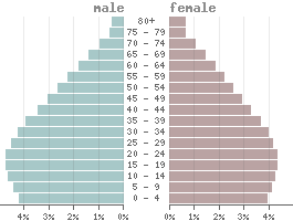
Population
Population pyramid
1 Rupee is divided into 100 Paise.
Status: 12/11/2025
1000 Rupees = 11.07 US dollar
Climate in India
India's climate regions vary from temperate in the north to subtropical in the centerto tropical monsoon regions in the south. The north is characterized by the foothills of the Himalayas. At high altitudesthere are snowfalls with alpine conditions in winter. Howeverthe summers are very hot with temperatures of up to 50°C. The central and southern parts of the country are hit by heavy rains from June to September. The high humidity then makes for an unpleasant sticky weather. Due to the influence of the Indian Oceanhowevertemperatures are lower and fluctuate between 25 and 35°C during the daydepending on the season. The rainy season begins around May and lasts until October.
Languages
India's nationwide official languages are Hindi and Englishwhile the constitution lists 22 "scheduled languages" (including Hindibut excluding English) with a special status. Each state can also define its own official languageswhich do not have to be one of these.| Mother tongue | Distribution |
|---|---|
| Hindi | 40.0 % |
| Bengali | 8.0 % |
| Telugu | 7.2 % |
| Marathi | 6.7 % |
| Tamil | 5.8 % |
| Urdu | 5.0 % |
| Gujarati | 4.4 % |
| Kannada | 3.6 % |
| Oriya | 3.2 % |
| English | 3.2 % |
| Malayalam | 3.2 % |
| Punjabi | 2.8 % |
| Bhojpuri | 2.2 % |
| Assamese | 1.3 % |
| Maithili | 1.2 % |
| other | 2.2 % |
Religions
| Religion | Distribution |
|---|---|
| Bahaists | 0.2% |
| Buddhists | 0.7% |
| Christs | 2.3% |
| Hinduists | 79.8% |
| Sunni | 9.5% |
| Shia | 3.5% |
| Jains | 0.4% |
| Sikhs | 1.7% |
| other | 1.9% |
Land use
| 7% Urban areas: | 222,688 km² |
| 60% Agricultural areas: | 1,987,148 km² |
| 24% Forest: | 797,818 km² |
| 10% Water areas: | 314,069 km² |
more...
Transport
| Roadways: | 6,700,000 km |
| Railways: | 68,988 km |
| Reg. vehicles: | 80,888,051 |
| › Airports: | 153 |
Economy
According to the definition from the International Monetary Fund (IMF)India is a developing country because of its lower economic performance. Despite this classificationthe country is currently also one of the emerging marketsi.e. countries with increasing industrialization.With an average annual income of 2,650 USD India is one of the lower middle-income countries.
| GDP: | 3,912.69 bn $ |
| Exportations: | 822.01 bn $ |
| Importations: | 923.56 bn $ |
| Tourism receipts: | 21.36 bn $ |
| › Debt rate: | 81.64 % |
| › Unemployment rate(ILOEST): | 4.20 % |
| › Inflation rate: | 4.40 % |
| › Corruption index: | 38 (bad) |
| › Energy consumption: | 1,500.0 bn kWh |
Existing trade agreements
Political indicators
| Political stability: | ◈ |
| Rule of law: | ◈ |
| Effectivity: | ◈ |
| Regulatory quality: | ◈ |
| Voice accountability: | ◈ |
| Autocracy Index: | ◈ |
| Death penalty: | Legally allowed |