Archaeological Site of Ani
Archaeological Site of Ani
This site is located on a secluded plateau of northeast Turkey overlooking a ravine that forms a natural border with Armenia. This medieval city combines residentialreligious and military structurescharacteristic of a medieval urbanism built up over the centuries by Christian and then Muslim dynasties. The city flourished in the 10th and 11th centuries CE when it became the capital of the medieval Armenian kingdom of the Bagratides and profited from control of one branch of the Silk Road. Laterunder ByzantineSeljuk and Georgian sovereigntyit maintained its status as an important crossroads for merchant caravans. The Mongol invasion and a devastating earthquake in 1319 marked the beginning of the city’s decline. The site presents a comprehensive overview of the evolution of medieval architecture through examples of almost all the different architectural innovations of the region between the 7th and 13th centuries CE.
Description is available under license CC-BY-SA IGO 3.0
Site archéologique d’Ani
Le site est situé au nord-est de la Turquie sur un plateau isoléen surplomb d’un ravin constituant une frontière naturelle avec l’Arménie. Cette cité médiévale associe des structures résidentiellesreligieuses et militairescaractéristiques d’un urbanisme médiéval construit au fil des siècles par les dynasties chrétiennespuis musulmanes. La ville connaît son apogée aux Xe et XIe siècles de notre èrelorsqu’elle devient la capitale du royaume médiéval arménien des Bagratideset tire sa richesse de la maîtrise de l'une des branches de la Route de la soie. Plus tardsous les souverainetés byzantineseldjoukide et géorgienneelle maintient son statut d'important carrefour pour les caravanes marchandes. L’invasion mongole et un séisme destructeur en 1319 marquent le début du déclin de la cité. Le site offre un large panorama du développement architectural médiévalgrâce à la présence de presque tous les types architecturaux qui ont émergé dans la région entre le VIIe et le XIIIe siècle de notre ère.
Description is available under license CC-BY-SA IGO 3.0
مدينة آني الأثرية
يقع هذا المكان في شمال شرق تركيا في منطقة معزولة مطلّة على واد يشكّل حدوداً طبيعيّة بين تركيا وأرمينيا. تعود هذه المدينة إلى العصور الوسطى وتجمع بين المباني السكنيّة والدينيّة والعسكريّة على غرار جميع المدن التي تعود إلى القرون الوسطى والتي شيّدت خلال عدّة قرون على يد المسيحيّين ثم المسلمين. ووصلت هذه المدينة إلى ذروة الازدهار في القرنين العاشر والحادي عشر بعد الميلاد حيث أصبحت عاصمة المملكة الأرمنية في العصور الوسطى على زمن الشعوب باغراتونية واكتسبت ثروتها من تجارة الحرير. وبعد ذلك، وعلى زمن البيزنطيّين، والسلاجقة والجورجيّين، أصبحت المدينة حلقة وصل مهمّة لقوافل التجار. وبدأت عظمة المدينة بالتهاوي بعد الغزو المغولي والزلزال المدمر عام 1319.
source: UNESCO/CPE
Description is available under license CC-BY-SA IGO 3.0
Археологический объект Ани
Данный объект расположен на северо-востоке Турции на изолированном плоскогорье с видом на ущельеобразующее естественную границу с Арменией. Этот средневековый город сохраняет жилыерелигиозные и военные сооруженияхарактерные для средневекового градостроительства. На протяжении веков Ани строился христианскимиа затем мусульманскими династиями. Расцвет города пришёлся на X-XI века н.э.когда он стал столицей средневекового Армянского царства Багратидов и разбогател за счёт взимания пошлин на одном из ответвлений Шёлкового пути. Позднеенаходясь под суверенитетом византийцевсельджуков и грузингород сохранял свой статус важного перекрестка торговых путей. Монгольское вторжение и разрушительное землетрясение 1319 года положили начало упадку города. Ани даёт общее представление о развитии средневековой архитектуры благодаря наличию сооружений практически всех архитектурных стилейхарактерных для региона в период с VII по XIII века н.э.
source: UNESCO/CPE
Description is available under license CC-BY-SA IGO 3.0
Sitio arqueológico de Ani
Situados al nordeste de Turquíaen una solitaria meseta erguida sobre el valle que delimita la actual frontera natural entre este país y Armenialos vestigios de la ciudad medieval de Ani comprenden un gran conjunto de viviendas y edificaciones religiosas y castrenses dotadas de una estructura urbanística típica de la Edad Mediaque se fue configurando a lo largo de los siglos bajo la soberanía de diferentes dinastías cristianas y musulmanas. La ciudad alcanzó su máximo esplendor entre los siglos X y XIcuando fue capital del reino armenio de los Bagrátidas y se benefició del control que ejercía sobre uno de los ramales de la Ruta de la Seda. Posteriormentebajo el sucesivo dominio de los bizantinosselyúcidas y georgianosconservó su rango de encrucijada importante del tráfico mercantil de caravanas. La invasión mongola de 1239 y el devastador terremoto de 1319 asolaron la ciudad y precipitaron su decadencia. Ani ofrece un amplio panorama del desarrollo arquitectónico medieval gracias a la presencia de casi todas las innovaciones arquitectónicas que emergieron en la región entre los siglos VII y XIII de nuestra era.
source: UNESCO/CPE
Description is available under license CC-BY-SA IGO 3.0
アニの古代遺跡
source: NFUAJ
Archeologische site van Ani
Source: unesco.nl

Outstanding Universal Value
Brief synthesis
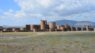
Ani is located in the northeast of Turkey42 km from the city of Karson a secluded triangular plateau overlooking a ravine that forms the natural border with Armenia. The continuity of settlement at Ani for almost 2500 years was thanks to its geographical locationon an easily defensible plateau that was surrounded by fertile river valleys at an important gate of the Silk Roads into Anatolia. This medieval city that was once one of the cultural and commercial centres on the Silk Roadsis characterized by architecture that combines a variety of domesticreligious and military structurescreating a panorama of medieval urbanism built up over the centuries by successive Christian and Muslim dynasties. Inhabited since the Bronze AgeAni flourished in the 10th and 11th centuries ADwhen it became a capital of the medieval Armenian kingdom of the Bagratidsand profited from control over one branch of the Silk Roads. Laterunder ByzantineSeljukand Georgian sovereigntyit maintained its status as an important crossroads for merchant caravanscontrolling trade routes between ByzantiumPersiaSyria and Central Asia. The Mongol invasionalong with a devastating earthquake in 1319 and a change in trade routesmarked the beginning of the city’s decline. It was all but abandoned by the 18th century.
The principal area of the property consists of architectural remains located in three zones: the citadelwhich includes the ruins of the Kamsaragan palacePalace churchMidjnaberd churchSushan Pahlavuni churchthe Karamadin church and the church with Six Apses; the outer citadel or walled city which includes amongst others the Fire TempleCathedralRamparts of Smbat IIEmir Ebu’l Muammeran ComplexSeljuk Palacedomestic architecturethe marketand the Silk Road Bridge; and the area outside the city walls. Rock-carved structures on the slopes of one of the valleys surrounding the citythe Bostanlar Creekare also part of the property.
Religious monuments of ZoroastrianChristian and Muslim influenceas well as public and domestic buildings in Ani provide a vivid and comprehensive picture of a distinctive relic medieval city which attests to the transmission and amalgamation of different architectural traditions that evolved in the CaucasusIranTurkestan and Khorasanand were translated into stone. This medieval settlement consists of remains from a multi-cultural centrewith all the richness and diversity of Medieval ArmenianByzantineSeljuk and Georgian urbanismarchitectureand art development.
Criterion (ii): Ani was a meeting place for ArmenianGeorgian and diverse Islamic cultural traditions that were reflected in the architectural designmaterial and decorative details of the monuments. New swhich emerged as a result of cross-cultural interactionshave turned into a new architectural language peculiar to Ani. The creation of this new language expressed in the designcraftsmanship and decoration of Ani has also been influential in the wider region of Anatolia and Caucasia.
Criterion (iii): Ani bears exceptional testimony to Armenian culturalartisticarchitectural and urban design development and it is an extraordinary representation of Armenian religious architecture known as the “Ani school”reflecting its techniques and material characteristics.
Criterion (iv): With its militaryreligious and civil buildingsAni offers a wide panorama of medieval architectural development thanks to the presence at the site of almost all the architectural types that emerged in the region in the course of the six centuries from 7th to 13th centuries AD. It is also considered a rare settlement where nearly all of the plan types developed in Armenian Church architecture between the 4th and 8th centuries AD can be seen together. The urban enclosure of Ani is also an important example of a medieval architectural ensemble with its monumentalitydesign and qualityas well as the tunnels and caves beneath Ani plateauwhich connect to the surrounding volcanic tufa setting of deep river valleys.
Integrity
All the elements that constitute the basic values of Ani are located within the boundaries of the property. Although the majority of structures having monumental characteristics are still standing on sitethere is not a single monument that is not facing serious structural problems of stabilityeither missing parts of the fabricdue to seismic action or human destructionor problems of unsuccessful interventions. The visual integrity of the landscape is affected by the quarrying activities on the east side of Arpaçay Creek and the inappropriate use of pasture areas of the rock-cut caves in Bostanlar Creek and Arpaçay Creek. The State Party is currently addressing the highly vulnerable state of conservation of key attributes of the property through the implementation of a comprehensive conservation strategy and action plan.
Authenticity
The remoteness of the uninhabited city of Aniwith its impressively standing monumental buildingsover an invisible landscape of underground tunnels and caves surrounded by deep river valleysprovides a mostly unaltered window onto the past. The property has also not undergone any modern development. Neverthelessearthquakesthe harsh climate and human destruction have affected the overall authenticity of the property. The level of authenticity of materialsubstanceand workmanship has been affected by large amounts of new fabric introduced in a number of restoration projectscausing loss to the original building fabric. On-going conservation practices have focused largely on addressing the effects of deterioration processes on the property with a stronger emphasis placed on carrying out interventions that maintain the qualities of the original materials and techniques as well as on removing the earlier improper interventions in a number of monuments.
Protection and management requirements
The archaeological site of Ani has been registered on the national inventory since 1988 as a 1st Degree Archaeological Conservation Site that is surrounded by a 3rd Degree Archaeological Conservation Sitewith continual enlargements in site boundaries. These registrations put the property under the protection of Turkey’s National Law No. 2863 for the Protection of Cultural and Natural Properties that requires approval by Kars Regional Council for the Protection of Cultural Assets of all plans and projects to be implemented in registered sites.
The Ministry of Culture and Tourismwhich is the main responsible government body for conservation and management of the siteis organized at both central and local levels. The General Directorate of Cultural Heritage and Museums centrally regulates the activities of its local branchesand fulfils certain tasks regarding monument restoration and World Heritage issues. Local branches that are relevant in this case are the Kars Regional Council for Conservation of Cultural HeritageErzurum Directorate of Surveying and Monumentsand the Directorate of Kars Museum.
Measures taken in recent years by the State Party have greatly protected the most important monuments of the property. A Conservation Oriented Development Plan for the two registered sites was approved in 2011through a process based on scientific principals and participation of stakeholders at different levels.
A Strategic Conservation Master Planprepared by the Ministry with scientific support from expertswas approved by the Ministry on 3 February 2016. It lists the provisions of all legal conservation documents related to the siteand includes an updated SWOT analysis as well as interrelated policies and principles that are reviewed in reference to the Management Plan. The Strategic Conservation Master Plan should be revised in order to present a more comprehensive needs assessment for each listed monumentas well as the required interventions and priority areasas the basis for conservation and monitoring of the property.
The Management Plan for the property was approved on 30 March 2015. Priorities set for the period 2015-2020 in the two plans include emergency measures against seismic and environmental risks to ensure the intact survival of monumental buildingscontext excavations and research to reveal their urban settingimprovement of visitor and research facilities at the siteenhancement of Ocaklı Village through better integration with the propertyand educational programmes towards these ends. A Heritage Impact Assessment approach should be integrated into the management systemso as to ensure that any project regarding the property be assessed in relation to its impacts on the attributes that convey the Outstanding Universal Value of the property.


The Nomination files produced by the States Parties are published by the World Heritage Centre at its website and/or in working documents in order to ensure transparencyaccess to information and to facilitate the preparations of comparative analysis by other nominating States Parties.
The sole responsibility for the content of each Nomination file lies with the State Party concerned. The publication of the Nomination fileincluding the maps and namesdoes not imply the expression of any opinion whatsoever of the World Heritage Committee or of the Secretariat of UNESCO concerning the history or legal status of any countryterritorycity or area or of its boundaries.